THE STANDING SENATE COMMITTEE ON TRANSPORT AND COMMUNICATIONS
EVIDENCE
OTTAWA, Tuesday, December 12, 2023
The Standing Senate Committee on Transport and Communications met with videoconference this day at 9:02 a.m. [ET] to study the impacts of climate change on critical infrastructure in the transportation and communications sectors and the consequential impacts on their interdependencies.
Senator Leo Housakos (Chair) in the chair.
[English]
The Chair: Good morning, honourable senators.
I am Leo Housakos, a senator from Quebec and the Chair of the Standing Senate Committee on Transport and Communications.
[Translation]
I invite my colleagues to introduce themselves.
[English]
Senator Simons: Hello. I’m Senator Paula Simons from Alberta, Treaty 6 territory. A very early, good morning to you all.
Senator Cardozo: Yes, a very early, good morning, and thank you for joining us. I’m Andrew Cardozo from Ontario.
[Translation]
Senator Clement: Hello. Bernadette Clement, Ontario.
[English]
Senator Quinn: Good morning. Jim Quinn, New Brunswick.
[Translation]
Senator Miville-Dechêne: Julie Miville-Dechêne, Quebec. Thank you for being here so early. We appreciate it.
[English]
Senator Dasko: Donna Dasko, senator from Ontario.
The Chair: Today, we continue our study of the impacts of climate change on critical transportation infrastructure, and begin our study of the infrastructure in Vancouver.
For our first panel, we are pleased to welcome officials from the Government of British Columbia’s Ministry of Transportation and Infrastructure, who are joining us by video conference. As my colleagues pointed out, thank you for getting up early this morning to be with us. We have with us Kaye Krishna, Deputy Minister; Kevin Richter, Associate Deputy Minister, Highways and Regional Services Division; and Kevin Volk, Assistant Deputy Minister, Integrated Transportation and Infrastructure Services Division. Welcome and thank you for joining us.
We’ll begin with opening remarks of five minutes. The deputy minister will begin, followed by questions from senators.
Deputy Minister Krishna, you have the floor.
Kaye Krishna, Deputy Minister, Ministry of Transportation and Infrastructure, Government of British Columbia: Good morning, chair and members of the committee. Thank you so much for the invitation to join you this morning. I’m joined by my colleagues from Victoria, British Columbia, which is part of the unceded traditional territory of the Lekwungen-speaking people, known today as the Esquimalt and Songhees First Nations.
You’ve asked for testimony regarding the impacts of climate change on transportation infrastructure in the Vancouver area — in particular, the Port of Vancouver and Vancouver International Airport — and the resulting impacts on supply chains. As their testimony will follow, I’ll speak more broadly to the impacts of climate change in British Columbia and in the Metro Vancouver area.
The impacts of climate change in British Columbia are real and increasingly damaging and costly for our communities, provincial infrastructure and the national and international supply chains. British Columbia has long been an international leader in anticipating and addressing the impacts of climate change on infrastructure. In 2015, we adopted our first resilient infrastructure design standards and adaptation to the impacts of climate change and weather extremes. We’ve been updating them regularly as the science, and our experience continue to advance.
In 2022, British Columbia published the Climate Preparedness and Adaptation Strategy which provides some of the latest work on our collective work here in B.C., including a new climate adaptation program to proactively replace and rehabilitate existing culverts.
Despite our proactive work over the years, we’ve seen that our infrastructure remains vulnerable to the increasing intensity and frequency of extreme weather events. We are also increasingly vulnerable to the compound effects that weather and climate change are having, such as the extreme heat and drought contributing to more severe wildfires which, in turn, contribute to greater landslide and debris flow risks during precipitation events, even smaller precipitation events.
We saw an example of this over the summer after the Cameron Lake Bluff wildfire near Port Alberni, which is near Highway 4 — the only highway to the west coast of southern Vancouver Island. The fire destroyed land on the steep hills above the highway. Once the fire was extinguished, the land was destabilized and we had to close the highway for weeks, cutting off supplies to communities and tourists until a technical netting system could be installed and safety was confirmed.
Of course, there was the atmospheric river event in November of 2021. That storm event effectively paralyzed British Columbia’s supply chain in a province where the movement of goods generates $16.3 billion in GDP and employs 140,000 people. That event effectively cut off the largest port in Canada from the rest of the Lower Mainland for over a week.
I would like to speak briefly about the key lessons from our ongoing work adapting to climate change and from the catastrophic events like the 2021 storms. The first lesson is that nothing gets accomplished if we don’t work together. It is amazing what can be accomplished when all parties are focused on the same goal, especially in an emergency, but we would like to see how we can do that on a day-to-day basis.
For a short period of time after the 2021 event, the partnership and sense of urgency among regulators, policy-makers, those in charge of infrastructure, shippers, stakeholders and other private partners showed us how some of the supply chain challenges could be overcome. This included the elimination of red tape that often accompanies permit processes, the sharing of vital and sometimes proprietary data and the access to senior decision makers on a real-time basis. Actions were taken at lightning speed, and the road and rail systems were up and running as quickly as anyone could have hoped for. If you recall, the ministry had the Coquihalla Highway between Vancouver and Kamloops — one of our major commercial corridors — open in 35 days. The permanent fixes have since been completed in less than two years, exceeding everyone’s expectations.
Through the National Supply Chain Task Force jointly hosted by Transport Canada and ourselves, and joined by many partners across the supply chain, we were able to find the most real-time solutions to supply chain challenges, such as being able to route commercial trucks through Washington State when the border was closed due to the pandemic.
I urge the committee to explore whether these experiences — particularly with respect to improving the processes for regulatory approvals and permits, as well as data and information sharing — can help us in the longer term to build a more resilient supply chain that’s better on a day-to-day basis and in the face of future events.
The second lesson I would like to share is that our supply chain is an integrated system. While the focus of this hearing is the Metro Vancouver area — in particular, the Port of Vancouver and Vancouver International Airport — the Port of Prince Rupert is Canada’s third-largest port and growing. It is a critical component of our national supply chain. We have waterfront facilities throughout the B.C. coast, inside and outside of the Port of Vancouver’s boundaries, including up the Fraser River and Vancouver Island. These opportunities and physical spaces can help with the loading and unloading of goods and adapting to emergency needs.
I encourage you to consider the British Columbia supply chain from a broader systems-based perspective, including the physical, technical and governing frameworks that connect us to other provinces, territories and countries. For example, the container terminal at Duke Point in the Port of Nanaimo is managed by the same terminal operator as the Fraser Surrey Docks in Vancouver. This creates opportunities when the supply chain is interrupted at one location to shift operations and move goods through a different route, and to think differently about how these goods can move — for example, unloading containers at one location, then barging them upriver to another location where road and rail connections might be less affected by an event and possibly less affected by the congestion in the Lower Mainland, and closer to the port on a day-to-day basis.
Likewise, physical infrastructure investment and reinforcement need to take a systems-based approach, considering grey and green infrastructure and how smart design can help add layers of redundancy and protection to our assets and communities. For example, in the Sumas Prairie, which was previously Sumas Lake, following the atmospheric river event and the overwhelming of Highway 1 — our major east-west corridor through the Fraser Valley — we concluded that the entire diking culvert, highway and berming systems, if working together better, could have helped manage the severity of the breaching of the dikes during that event.
If we could think more critically about green infrastructure as well as grey infrastructure, and take a systems-based approach to how we’re designing and investing in systems-based infrastructure, we will all benefit.
Finally, British Columbia has responded to the emerging impacts of climate change and climate events by restructuring our government to facilitate coordination and decision making. For example, B.C. is currently participating in a 4G table on the Sumas Prairie — which is the example that I previously mentioned — as well as a second table with the United States in Washington State on identifying a systems-based strategy for building resilience in that region. The newly created Ministry of Emergency Management and Climate Readiness is the province’s leading and new coordinating agency for all emergency management activities, including preparedness, response, recovery and enhanced resilience. I’d also like to acknowledge the governance changes within the federal government, particularly the establishment of the National Supply Chain Office with Transport Canada. British Columbia fully supports this initiative, and we’re working closely in partnership with that office. As part of our work and coordination with them in our broader provincial framework, the Ministry of Transportation and Infrastructure is leading several key initiatives guided by a goods movement action plan. Those include a province-wide assessment of climate readiness, as well as potential impacts and risks to our highway networks; data collection and economic modelling to enhance our decision making on infrastructure investments in climate readiness; multi-jurisdictional engagement on the future of Highway 1 through the Fraser Valley; and, our partnership with Infrastructure Canada on the 2023 release of the guide to implementing systems-based approaches to climate-designed infrastructure.
In summary, I would like to reiterate to this committee that British Columbia is a committed partner with the federal government and all our partners across the supply chain in the ongoing efforts to mitigate and adapt to climate change. For over a decade, we have been leading the way in adapting our infrastructure and planning for weather events in partnership with the federal government and our private and public sector partners. We remain a strong and reliable partner to ensure that we, as well as our infrastructure and our communities, are prepared for the future. British Columbians expect nothing less. Thank you.
The Chair: Thank you very much. I will launch our question-and-answer session now.
Senator Simons: Thank you very much, Ms. Krishna.
I had the privilege of serving on the Standing Senate Committee on Agriculture and Forestry when we did a major study about the flooding of the Sumas Prairie. One of the issues that came up in that study was the question of whether the dikes were maintained by municipalities or by the province.
Could you speak to whether it might make more sense — given that dikes and other climate-mitigation infrastructure has an impact on the entire province — to return responsibility for the maintenance of that infrastructure to the provincial government rather than relying on individual municipalities to maintain such vital dike works?
Ms. Krishna: Thank you for the question, senator.
That is something that the province has been looking at. It is not something that the Ministry of Transportation and Infrastructure is leading; instead, it is in partnership with the Ministry of Emergency Management and Climate Readiness; the Ministry of Forests; and the Ministry of Water, Land and Resource Stewardship — and in partnership with the local governments, which maintain many of the dikes, as well as private landowners.
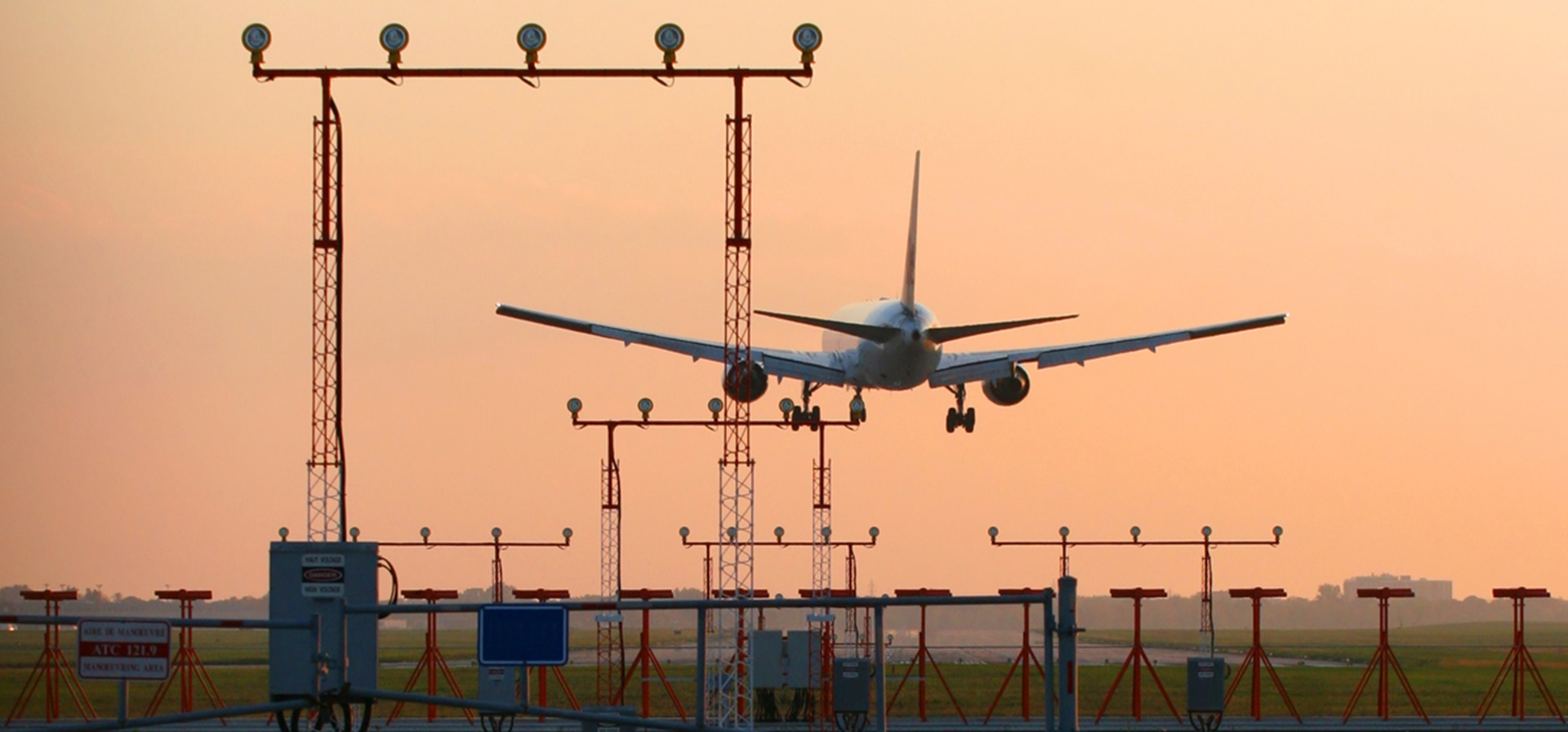
Senator Simons: In speaking to us today, you primarily focused on the larger issue of supply chains. Because of the nature of our study, we’re doing a micro focus on specific areas. One of those areas is the Vancouver airport. We’re seeing disturbing projections about the fact that the Vancouver airport — I speak as an Albertan — is absolutely vital for all of Western Canada. There are concerns that, because of its location on Sea Island, it could be vulnerable — not just to the kinds of terrible storm events that we saw last Christmas, but also to the eventual sinking of the airport into the sea.
In the short term, it’s great to have supply chain resiliency, but, in the longer term, what is the province looking at to ensure that such vital pieces of infrastructure are not literally swamped by rising sea levels?
Ms. Krishna: Thank you for the question, senator.
I understand that Vancouver International Airport, or YVR, is presenting after us today, but we work very closely with YVR, as well as our other entities that support the supply chain — in this case, passenger travel — to look at all of the work that we can do together to protect our critical assets in B.C.
Senator Simons: Could you tell us a little bit more about what that looks like? Are there talks about a long-term plan for a new airport location? Are there talks about investments in diking? I just wonder if you could get a little more specific than that “talk” line.
Ms. Krishna: Thank you, senator. As the Deputy Minister of Transportation and Infrastructure, that’s not something that we are currently engaged in, and I’m not able to answer your question with any level of detail. I apologize.
Senator Simons: If you’re not focusing on the airport — as the Deputy Minister of Transportation and Infrastructure — is your focus primarily on highway or rail? Where does the province’s ambit lie, then, if not the airport, which I understand is not a provincial jurisdiction? Where are you most critically focused on ensuring that the transportation infrastructure is sustainable?
Ms. Krishna: We have principal responsibility for roads, highways, bridges and tunnels. We also have oversight over transportation services authorities, such as TransLink — which is the transit authority in the Lower Mainland — B.C. transit ferries and ferries of some cargo, as well as the relationships with the port and the airport, and also with the rail and commercial trucking agency.
Our principal assets and accountabilities are for our physical road network that supports the movement of goods. Then, we’re coordinating with all the partners who are accountable for their respective assets. We’re working together to ensure resiliency and redundancy across the supply chain.
It is the critical role of Transport Canada to help bridge that in a more structured regulatory way.
Senator Simons: Thank you very much.
[Translation]
Senator Miville-Dechêne: I’m surprised that Transport Canada doesn’t seem to have any power over catastrophic flood prevention and response at Vancouver’s port and airport; that amazes me. I thought that was Transport Canada’s responsibility.
I’m also interested in roads, because they’re everywhere. What kind of prevention studies have you done to deal with potential catastrophic flooding of the entire area around Vancouver airport, the Port of Vancouver and municipal roads?
[English]
Ms. Krishna: Thank you for the question, senator. I will provide an initial response, but I’ll ask my colleagues — including Kevin Richter, our Associate Deputy Minister who is responsible for our highway network — to chime in.
Yes, this is part of the systems-based approach that I was referring to. While we don’t have accountability for the port, the airport or other private infrastructure, we do work very closely with those entities, especially the port and the airport, on road access.
For our highway system, we have a very proactive approach to looking at climate risk and resilience, among other risks, to our highway network — and building in technical design from an engineering point of view, where we do see high risks from a climate point of view. We’ve been doing that for years. It’s really about how we’re designing our highways and looking at our highways, bridges, roads and connecting roads as part of that broader system in our responsibility for ensuring that our part of that system is functioning and protected.
Kevin Richter, is there anything else you would like to add?
Senator Miville-Dechêne: Could you be a bit more specific on what you did and what it looks like? I would like more than just generalities. What is the plan and how are you trying to prepare for a flood?
Kevin Richter, Associate Deputy Minister, Highways and Regional Services Division, Ministry of Transportation and Infrastructure, Government of British Columbia: Thank you for the question. I will build off Ms. Krishna’s response with more specifics.
We currently have a funded climate resilience program of about $345 million over the next 10 years. With those funds, we are able to look at corridors in the Lower Mainland. Through our preservation and rehabilitation program, we look at the bridges and culverts, and assess them with the new climate adaptation policy to see how they can handle the changing climate either through precipitation or changing water levels. We look at a holistic system of our road network, bridges and culverts in the Lower Mainland. We do these engineering analyses to make sure they are resilient. If we find deficiencies, or see where it fits in with our rehabilitation program, that’s where we undertake works to replace the culverts, to modify the way the water flows through ditches or even to look at the bridges.
I don’t have specific projects, but this year, on our climate adaptation program, we did about 60 projects all around the province where we tried to improve the resiliency of the network.
Ms. Krishna: I can add to that. In addition to the physical and capital investments we are making — that Mr. Richter referred to — we’re pursuing a number of other things. I mentioned our goods movement action plan. Part of that work is looking at and identifying critical infrastructure for the supply chain throughout the province in the Lower Mainland, but also higher. I recognize that you’re looking at this area in particular, but we’re looking at both the Port of Prince Rupert and the Port of Vancouver, and where the critical infrastructure is for those ports and the access in and out of the province. We’re also looking at how we can come up with a strategy in partnership with Infrastructure Canada and Transport Canada — and, frankly, with the other Western provinces and territories who are part of this broader network — on how we can identify, validate and reinforce the critical infrastructure in this area, and where we can find redundancies across the area. Therefore, it is really in partnership with all those other entities that we are identifying and figuring out where we would agree the critical infrastructure is.
The second thing that we’re doing is working on data and information sharing on the physical network, as well as with the different partners — and how we share information — so that in anticipation of an event, during an event and following an event response, we’re all very well prepared and coordinated with information sharing in real time.
Senator Miville-Dechêne: If there is a flood, and there is water everywhere — I understand you’re building ditches and you’re trying to prepare — what’s the plan to move around the ground? If it’s all flooded, what do you do?
Ms. Krishna: It really depends on the event. The response to a flood is really led by the Ministry of Emergency Management and Climate Readiness for B.C., but we have a critical role in that. Mr. Richter can certainly speak to the activities that we pursued during and after the atmospheric river event, as well as with any other major events such as major snowstorms, which we saw last November and which had a pretty significant impact on travellers, commercial activity and the supply chain in the Lower Mainland for several days.
Mr. Richter, do you want to give some specific examples of, say, the tiger dam or other things that we did in response to that flooding event?
Mr. Richter: Absolutely. In an event such as a flooding event, for example, we have maintenance contractors available. Our road and bridge services are administered by maintenance contractors. The maintenance contractors have access to countless other contractors within the province. That worked well for us in our atmospheric river event. We could draw on hundreds of people, and thousands of pieces of equipment across the province were mobilized. We were bringing in equipment from northern British Columbia to help us in the Fraser Valley and on the Coquihalla and other roads impacted by floods or erosion. So in the event of flooding, we mobilize our equipment. We have ready access to equipment. We look at trying to prevent further inundation. Ms. Krishna referenced that we used a tiger dam, which was actually installed with the cooperation and assistance of the Canadian Armed Forces. If we can, we try and divert the water through the use of engineering technologies like the tiger dam. We also try and route traffic differently and try and manage through detours. We have key links within the Lower Mainland, but we work closely with TransLink and their major networks.
We have plans in place for the identification of major disaster event routes, which are used not only in the event of flooding or those climatological issues but also in the event of those large seismic events that could impact our infrastructure. We do have plans for rerouting and also have access to equipment, and we also have at our disposal novel engineering techniques to try and retain key corridors.
Senator Quinn: Thank you, witnesses, for being here this morning. I’m going to zero in on the Sea Island area — the airport — and Roberts Bank. Deputy, we’ve heard from other witnesses about sea level rise and the numbers and how they’ve changed over the last number of decades. I’m wondering what the situation is around Sea Island in particular, where the airport is, with respect to, say, 30 years ago versus today. What’s the sea level rise? What’s the number that you’re looking at?
Ms. Krishna: Thank you for the question, senator. Again, as a deputy for transportation, I don’t have those numbers on the sea level rise. That really sits with our ministry of environment. I would say that folks from YVR are in a better position to speak specifically about that for YVR.
Senator Quinn: Yes, I appreciate that. The port and the airport are vital to B.C.’s economy, but they’re also vital to Canada’s economies. They are key exchange points — if you will — locally, nationally and internationally. It just seems that the leadership on such an important file as climate change with respect to its immediate impacts and longer-term impacts on transportation seems to be — there are multiple players, but who’s providing the direct leadership? Who’s causing people to look at these things? We’re hearing that the third runway at Vancouver International Airport, for example, needs to be changed. I don’t believe the runway is that old. Who from British Columbia provides the direct leadership, bringing parties together and causing discussions and the formation of action plans and strategies to address climate change, specifically in the Sea Island area?
Ms. Krishna: Thanks again for clarifying the question, senator. As I mentioned, it would be the Ministry of Environment and Climate Change Strategy. We all work very well and closely together across the province. We have a climate preparedness and adaptation strategy that was published in 2022 by the ministry of environment. If you reference that report, you will see a series of chapters on different areas of consideration and different priority initiatives and how we’re all coordinating across British Columbia around climate adaptation and resilience. It really sits with that ministry to coordinate on behalf of all of B.C., inclusive of Sea Island but also looking at the entire coastline from a systems-based point of view.
Senator Quinn: Is your department part of the multi-level government committee or group that focuses exclusively on climate change and developing resiliency plans and action plans to take mitigation action and prevent the effect of climate change with respect to critical transportation infrastructure?
Ms. Krishna: Yes, we participate in various working groups to look at the critical infrastructure across the province with the federal government and other partners.
Senator Quinn: All right. Thank you.
Senator Dasko: Thank you to our witnesses for being here today. I understand that in November the Vancouver International Airport and the B.C. government announced a combined investment of more than $3.5 million from the federal and provincial governments for a clean energy project.
Could you describe in more general terms whether you engage with the federal government in programs like this on an ongoing basis? I’m trying to get a sense of the involvement of the federal government in dealing with these issues.
Are there any other similar projects where the feds have worked with the province on these infrastructure and environmental projects? Thank you.
Ms. Krishna: Thank you for the question, senator. I will ask Kevin Volk, who is our Assistant Deputy Minister responsible for programming and interfacing with Infrastructure Canada and Transport Canada to provide you with specific examples. But the short answer is yes, we do work closely.
Specifically for transportation, we have worked with Transport Canada on the National Trade Corridors Fund, for example, to invest in the highway and roads network that helps support the supply chain.
We have also been working very closely with Infrastructure Canada on their critical asset inventory and ongoing work with that organization on different funding programs that they provide. They are tying resilience more and more to those funding program conditions.
Mr. Volk, could you provide one or two different examples specifically on work that we have done with the federal government?
Senator, that clean energy announcement that you mentioned would also not be with Transport and Infrastructure but probably would have been with energy, mines and low-carbon innovation for our environment ministry with YVR, so we can’t speak specifically to that program, but we can give you other examples of work that we are doing with the federal government.
Kevin Volk, Assistant Deputy Minister, Integrated Transportation and Infrastructure Services Division, Ministry of Transportation and Infrastructure, the Government of British Columbia: Thank you, Mr. Krishna. Yes, the province of British Columbia has several partnerships with Infrastructure Canada and others. The most exciting and interesting is the partnership between the B.C. Innovation Commissioner and the federal government where we have established test beds at YVR, the Port of Prince Rupert, and the Port of Vancouver, where we invite innovators to come forward and test their technologies in a program that’s co-funded between the federal government and the provincial government.
The example that you have cited about testing out electrification at YVR is one of those examples. We have similar examples at Prince Rupert as well where we’re looking at applying low-carbon vehicles and other types of technology in those areas. If YVR is speaking to you later, they can provide more specifics on that.
Senator Dasko: Sounds great. Wonderful. You share a border with the Americans and a coastline as well. I wonder if you have any cross-border initiatives dealing with infrastructure issues with the Americans.
Ms. Krishna: Yes, as I mentioned briefly in my remarks, particularly as it relates to the Sumas Prairie. The Sumas Prairie is connected to the Nooksack River which flows into B.C. from Washington State. We have an active dialogue between ourselves, Washington State and the federal government of the U.S., specifically on opportunities to improve and mitigate the impacts of overflowing of the Nooksack into the Sumas Prairie. That’s in parallel with the work I mentioned around the 4G table that we also have that’s looking at the Sumas Prairie.
Senator Dasko: Thank you.
Senator Cardozo: I note looking out of the window behind you, Deputy Minister Krishna, that it’s pitch dark outside, so I really appreciate all of you being here.
You talk about Prince Rupert as part of the system. I wonder if you could educate us, me a little more. I had a really fascinating tour of the Port of Vancouver. Having been to Vancouver many times and spent a fair amount of time there, I’ve never really seen Vancouver from that angle and had no idea that there were so many terminals. My guess is there’s something like 30 or 40 terminals within the Vancouver Fraser Port Authority.
Do you know what the figure is in terms of how many terminals? How does that compare in terms of size to Prince Rupert? What is the physical connection between the Vancouver area and Prince Rupert? Looking at the map there isn’t a coastal highway. It would go further inland and then almost east over to Alberta. Could you educate me on some of that, please?
Ms. Krishna: Certainly. Thank you, senator, for the question. Kevin Volk may have some specifics on the size and the volume coming in and out of Prince Rupert.
It’s less about the connectivity between the Port of Vancouver and the Port of Prince Rupert and more that Prince Rupert is actually the shortest distance to Asia from Canada. It is approaching being the second-largest port in Canada. Right now it’s Vancouver, then Montréal, then the Prince Rupert Port, just to give you a sense of scale. It is currently the third-largest port in Canada, but inching up as the second and growing.
It’s a really critical port for east-west across northern Canada. There’s a lot of material that flows from western provinces and territories. There’s a lot of focus on mineral and gas exports. There’s quite a bit of activity there at the terminal.
Mr. Volk, do you want to elaborate on some of the specific goods that are exported as well as any volumes that we may have?
If we don’t have them offhand with us today, senator, we can follow up to the committee with some more details.
Senator Cardozo: Just one more question to you before we go to Mr. Volk. You’re not talking about goods coming from B.C. that would necessarily go through Prince Rupert, but points further east, such as Alberta and even all the way to Ontario that would find it easier to get there and then ship stuff out from there as opposed to the goods coming through Vancouver. I suppose there’s less traffic and all that, but it does seem like an awfully long highway to get there.
Ms. Krishna: There’s also rail.
Senator Cardozo: Okay.
Ms. Krishna: And the highway does cut across. Highway 16 is the critical link on the western side, but it goes through the northern cities of B.C., but there’s quite a bit of energy, mines and mineral extraction across that part of the province.
Rail is actually a very effective way, as is trucking. It’s really just different locations and what the routes and goods are, that are being exported.
The Vancouver Port has opportunities to work in more of a networked way up the Fraser River, but also with the Port of Nanaimo on southern Vancouver Island, and so that’s more of the network I was referring to. The network is well into the provinces and territories east, there are really two different major hubs, both within B.C.
Senator Cardozo: Okay. Thanks. Mr. Volk was going to add in terms of the size of the ports?
Mr. Volk: Yes, thank you. Prince Rupert, with respect to its container terminal, can currently handle about 1.6 million TEUs. It is the third largest by capacity in Canada. With their expansion, they are looking to become the second-largest container terminal in Canada. That is really a container import terminal.
It’s the shortest sailing distance from Asia to Prince Rupert. It allows the goods, once they are unloaded at Prince Rupert, to travel on the CN railway to points in North America, Chicago, Memphis and elsewhere.
The most recent focus for the Port of Prince Rupert has been on the export side. There has been significant investments, including investment by the federal government, on an export logistics park, which is a large rail loop that will allow all types of export facilities to be able to easily move goods from Saskatchewan, Alberta and British Columbia to be exported through Prince Rupert, including grain, coal and other commodities.
Senator Cardozo: Coal would be in containers?
Mr. Volk: No, it would be bulk.
Senator Cardozo: It would be bulk, okay.
Deputy Minister Krishna, as I understand it, the ports and YVR are not your jurisdiction. Those are federal jurisdiction. In terms of the areas that are your jurisdiction, which are the areas that are of most concern to you, be it highways or other areas that are low lying or most subject to catastrophic climate change? I’m thinking of the highway that was interrupted a couple of years ago. Which of the areas are of most concern to your government?
Ms. Krishna: Thank you for the question, senator. We are in the process of doing that critical hazard and risk mapping now. We are doing it in partnership with Infrastructure Canada and Transport Canada, as well as with the Western provinces and territories because their exports are reliant on our supply chain physical infrastructure.
We certainly know about things like Highway 1 through the Sumas Prairie, which we are working on now. We’re currently widening that highway. It’s really through the Fraser Valley. The Sumas Prairie is the piece that flooded, which you’re referring to. With respect to the segment that flooded, we have actually stopped just short of our widening project to further study that and evaluate a robust and resilient design for how we would expand or elevate or whatever the solution may be for that critical highway through our province. We are acutely aware of that.
We also know, and we haven’t talked much about this, but the issues of the geotechnical challenges in British Columbia are real. Kevin Richter is a geotechnical engineer by training. Some of the challenges that we face — I mentioned the example of the Cameron Lake Bluffs, whereas in the Fraser Canyon, which is where Highway 1 cuts up through the canyon, the challenges of steep cliffs adjacent to our highways and the impacts of things like drought and fire on the land adjacent to our road network is probably my greatest concern because it’s not necessarily within our control to the same degree as our physical infrastructure itself.
That’s part of the work that we’re doing, looking at the multitude of risks across our system and where we think the greatest risks could be. There’s quite a bit of data analysis as part of that. We’re also looking at our own assets, specifically like bridges or just the entire supply chain network, doing surveys around the economic impact of goods that are moving across them on a regular basis, what the impact would be to particular assets if something happened to them. We’re trying to really get a handle on what the risks and the economic impact are and what the alternatives to using those assets are. If one asset is compromised by an event, what could the rerouting or other alternatives be? What’s the redundancy of the system if certain critical impacts occur to critical assets?
Senator Cardozo: With regard to Roberts Bank, which is the expansion of the terminal, again, that’s not your responsibility, but is that being built in a way that will be more resistant to extreme climate?
Ms. Krishna: Thank you, senator. Because the port will be joining you, I would defer to them specifically on how they are designing that. I will say that between the federal and the provincial environmental reviews, which were very robust over several years, there was a lot of attention paid to both the environmental impact as well as the resilience of the design of that is my understanding. But again, I would defer to the Port of Vancouver to answer that specifically for you.
Senator Cardozo: That’s very helpful. Thanks.
Senator Simons: I wanted to ask two questions. One is about the Coquihalla highway. During that atmospheric river and the flooding in November 2021, I think about 100 kilometres of the Coquihalla was temporarily destroyed or taken over by landslide. As you mentioned, you were able to get that road reopened in 35 days, but it runs through a challenging part of British Columbia, which is quite vulnerable to climate disaster. I wonder if you can tell us what you’re doing to reinforce that critical piece of infrastructure.
Then following up on what you just said about the geotechnical, we haven’t talked about earthquakes because, of course, earthquakes are not a function of climate change, but you raise the point, that when cliffs and banks have been affected by drought and fire, they are a little more fragile. I don’t know if you or your team can talk about the intersection of climate change and earthquake risk and if you have to be particularly focused on that because of climate change factors. You can start with the Coquihalla and then talk about earthquakes.
Ms. Krishna: Yes, thank you. I will ask Kevin Richter to speak about the design and the approach that we have taken with the Coquihalla. We have redesigned all of the bridge replacements on that highway with resilience in mind. We have taken a very different approach to how we have replaced and redesigned the bridges based on our experience.
I also suggest that Mr. Richter is probably the best equipped to answer your question on the intersection of earthquakes and climate events, though I would say we are not really experts in this regard, so there are probably more experienced scientists or technicians who can answer that specifically. I’ll leave it to Kevin to determine if there’s anything he can add there.
Mr. Richter: With regard to the first question in terms of the Coquihalla, I don’t know the precise number of kilometres of the Coquihalla that were removed, but I know that there are 30 sites and 6 bridges that were damaged or destroyed, so they weren’t operational.
In the new design, we have definitely taken a climate resiliency approach. Part of the challenge presented to us with the atmospheric river was that the bridges prior to the event were constructed in the 1980s on the spread footing, so they were built on the ground. In the new design, we have gone in and replaced all those foundations with piles, which are metal pipes that are driven into the ground. They are driven to depth, so even if there’s erosion of the channel, the bridges will stay high and supported by these piles or these gigantic pipes that we have driven into the ground.
In the reconstruction, we also looked at hydrological models. There were big forest fires in the Coquihalla; we looked at the impacts of those fires but also potential future fires. In the hydrological modelling, we did some modifications to the spans. In a couple of locations, we actually changed the length of the bridges. We increased the length of the bridges to allow more water to flow through.
We also looked at how we armoured the channel. We refer to it as rip-rap, which is the placement of big rocks. If you look at a foreshore or a river environment, you’ll see big rocks or blocks that are placed on the slopes. We looked at our hydrological design of that armouring or rip-rap, and we actually made it a lot stronger. We also tried to do modifications to sort of train the river, as best we can, so that for any future events, these bridges would be in great shape in anticipation of any future floods.
We also looked at the hillsides, and we have been taking a holistic view as a result of wildfires of how we can work with our brother-sister agencies in the watershed restoration. The way the water runs off from a high-intensity storm event is quite quick. It fills the river up and the river goes down and washes everything apart. Also, by re-vegetating the slopes, we try to minimize the impacts and risks of debris flows or rockfall events or any slope natural hazard that could occur. We don’t only look at the behaviour of the river itself, but we look at the watershed and the slopes surrounding the Coquihalla and what we can do to protect those. It was not only the Coquihalla, but it was Highway 1 through the Fraser Canyon and then Highway 8 connecting Spences Bridge to Merritt.
Perhaps I will tag team with my colleague with regard to the intersection of seismic and climatological events. As a practising engineer, we do look in our designs at the effects of climate, but we also look at the effects of seismic forces, accelerations and velocities that the ground will exhibit. When we’re looking at slopes or at bridge structures, we do look at it. British Columbia is a large province, so the seismic risks vary throughout the province, both in magnitude but also in the conditions. We do take into account, as a part of our designs, that intersection of climate and seismic.
I’ll turn it over to my colleague who has under his wings, the engineering group and the chief engineer. Kevin Volk?
Mr. Volk: Yes, I would agree with Mr. Richter. Certainly, both national and provincial engineering standards continue to evolve and improve both with respect to adapting to climate change and the seismic design, which, as Mr. Richter mentioned, is very pertinent in British Columbia, particularly on the coast. Modern structures will always be designed to the highest earthquake standards.
With respect to existing infrastructure — and there is provincial infrastructure out there, for example, the causeway that links to the Tsawwassen Ferry Terminal, which is built on fill-in at Roberts Bank, and we know that it was constructed to different seismic standards, as was all infrastructure that was constructed during that time. It remains something that we need to assess from a risk perspective and a mitigation perspective as we go forward.
We’re in plans right now to replace the George Massey Tunnel, an immersed tube tunnel that was constructed in the 1950s, and one of the drivers for the replacement is to ensure that the new modern tunnel meets existing and future seismic standards. Thank you.
[Translation]
Senator Miville-Dechêne: I have a question for our engineers. In our study, we heard from experts, especially when we looked into the Chignecto Isthmus, who advocate nature-based solutions to counter the harmful effects of climate change on infrastructure. One of them involved reverting marshlands to their original state and moving the dikes back.
Have you considered nature-based solutions in British Columbia? You briefly touched on that when you talked about hills and slopes. Are there any other interesting initiatives?
[English]
Ms. Krishna: I can jump in. I know you directed this to the engineers, and I welcome them to join as well. In the Sumas Prairie specifically, we are definitely looking at grey-green infrastructure and systems design. That is the area where the flooding took place after the atmospheric river went through the Fraser Valley and overwhelmed Highway 1. We, ourselves, are looking, with the local governments, the First Nations, and the federal government, at a much broader systems design. We are looking at the diking structures around the canal and the Fraser River. We are looking at how our highway could play into the design of a broader regional strategy. We are looking at other opportunities for berming and green infrastructure to reinforce an overall system for that Sumas Prairie. That’s just one example, and we’re in the process of designing that now.
Mr. Richter or Mr. Volk, are there other examples that you would like to share? Maybe Highway 8, Mr. Richter?
Mr. Richter: On Highway 8, we have been working closely with the First Nations. There are five First Nations in the corridor between Merritt and Spences Bridge, and we have been the benefactors of working with the First Nations communities on how they see the whole system working. As we have been doing the repairs and as we are looking forward, we are looking at where we can do habitat improvements or where we can mesh the return of the road system to what’s happening naturally in the area, in conjunction with advice that we’re receiving from the First Nations. It’s the construction of zones, groynes — those are things that are in the river to prevent erosion — creating backwater eddies for spawning habitat, because it was all destroyed when the storm event went through.
So with the direction of the First Nations, looking at areas where we can create habitat for returning fish, looking at areas where there is traditional harvesting of vegetation. There’s a lot of asparagus that I found out that grows along the Nicomin River, and so returning those areas and reconstituting those areas for traditional use of the First Nations.
For me personally, as an engineer, I am learning a lot from the Indigenous communities, First Nations communities on our engineering designs and on how we can work with nature to ensure that it can be resilient in the future but also meet the needs of the First Nations communities. Thank you.
Ms. Krishna: Senator, if I may, I would suggest that this is an area of opportunity across Canada to think more about grey-green infrastructure design. Having seen the best practices in other jurisdictions, there’s more we could probably do. And, as Mr. Richter said, there’s a lot we can continue to learn from First Nations in this regard. The challenge — and we’re working through it, as you can see through some of the examples. We’re very intentionally working with First Nations, our other Crown agencies that have jurisdiction over the land and other private partners on this systems-based, nature-based design with our grey infrastructure.
Often, the challenges around capital projects and funding is that they are usually focused on the grey infrastructure. So there’s a bit of a change journey that I would suggest we’re all endeavouring upon regarding how we think about designing and funding these projects, to ensure that the examples that Mr. Richter provided of the land, the water, the rip-rap, the interventions and the plantings and other things to stabilize the land and to steer the rivers and support the ecosystems — that’s considered part of a project. Traditionally, that’s not how capital projects are structured or funded.
The Chair: This brings to a conclusion our first panel. On behalf of the committee, I would like to thank Ms. Krishna and Mr. Volk and Mr. Richter for appearing before this committee today and sharing your views.
For our second panel, we are pleased to have with us by video conference Christoph Rufenacht, Vice President, Airport Development and Asset Optimization from the Vancouver Airport Authority. He is accompanied by Wendy Avis, Director, Climate and Environment; and Trevor Boudreau, Director, Government Relations. Representing the Vancouver Fraser Port Authority, we’re also joined by video conference by Ronan Chester, Director, Climate Action and Sustainability Leadership.
Welcome, and thank you for joining us. We’ll begin with opening remarks of five minutes each from Mr. Rufenacht, followed by Mr. Chester. Then we will proceed to questions and answers.
Mr. Rufenacht, you have the floor, sir.
[Translation]
Christoph Rufenacht, Vice President, Airport Development and Asset Optimization, Vancouver Airport Authority: Thank you for the opportunity to make my presentation to the committee.
[English]
I am joining you today from my office at the Vancouver International Airport, or YVA, which is located on the traditional, unceded and continuously occupied territory of the Musqueam Indian Band. Before I begin, I wish to pay my respects to elders both past and present.
Honourable senators, YVR, as you may know, is recognized as a leader in climate action and adaptation. Our climate advocacy plan to become net zero by 2030 is well under way and on track. We have invested extensive time and resources to better position YVR and the community we serve into the future.
At the same time, we face immediate threats from the impacts of climate change. As a result, we are making investments to mitigate and adapt to these changes to ensure the long-term resiliency of critical transportation and trade infrastructure that we operate.
Just a few short weeks ago, BC Hydro release a report that revealed a striking reality: Most of the worst storms that BC Hydro has had to contend with occurred within the last five years. That is our reality at YVR. In the last two years alone, our team has managed through everything from heat domes and dry summers to extreme cold and severe snowstorms. In late November, atmospheric rivers, pooling water and king tides again converged on our region.
Climate change is directly responsible for the significant increase in severe weather events across our province, and that is something for which YVR is extensively preparing.
Given YVR’s geographic location, there is a significant risk to YVR’s operations associated with sea level rise and the occurrence of more intense rainfall and windstorms, combined with king tide events. Today, we use gravity discharge for about 80% of our storm water management. As waters rise, that becomes less effective, so there is more pressure on our pump station infrastructure to manage drainage effectively.
These events also present increased risk potential for cascading events. For example, the interruption of electrical supply because of a flood or severe windstorm that impacts power could undermine our ability to pump excess water off Sea Island during a storm event.
Over the next two to three years, YVR will be continuing to aggressively invest in our local infrastructure. That includes increasing the height of our dikes and upgrading the eight pump stations on Sea Island to install new equipment with improved efficiency and capacity. We are also exploring a new energy strategy that will improve YVR’s resilience in times of local power outages.
Operations at YVR have remained largely resilient to weather impacts thanks to careful planning and proactive investments. That includes collaborating with regional and provincial governments on climate modelling and risk analyses. We know that transportation infrastructure is an ecosystem, so it is critical that all modes work together. For example, in the aftermath of the catastrophic 2021 atmospheric river event, aviation was the only mode that remained open. Our sector adjusted to provide additional support to move people and goods while highway and rail infrastructure was being repaired.
As we collectively look at future infrastructure investments, we are planning collaboratively with the B.C. government and local communities. That will ensure that enhanced air cargo capacity enables a more robust and resilient multimodal movement of people and goods.
The last few years have also been drier and hotter. We know that our physical infrastructure in some areas of the airport and airside operations do not perform as optimally as possible in such hotter temperatures. Due to this, we have begun preparations, including the rehabilitation of infrastructure on our south airfield and other climate-resilient airside upgrades.
As we engage in further dialogue on this important topic, I want to highlight the importance of the Government of Canada as a key partner in planning and mitigating impacts of climate change on critical infrastructure. We are ready to meet future challenges and are making proactive investments to decarbonize and adapt to the new realities imposed by climate change. The federal government is an important partner in this work, and we are grateful for the government’s ongoing support as we prepare for the future together.
We will continue to work closely with all key government stakeholders as we pursue our common goal: to deliver modern and resilient transportation infrastructure for Canadians and to support Canadian businesses to grow trade and investment.
Thank you for the opportunity to speak today. I look forward to taking your questions.
The Chair: Thank you. I will now turn the floor over to Mr. Chester.
Ronan Chester, Director, Climate Action and Sustainability Leadership, Vancouver Fraser Port Authority: Thank you and good morning.
The Vancouver Fraser Port Authority is the federal agency responsible for management of the lands and waters that make up the Port of Vancouver. But before going further, I would like to recognize that I am calling from the traditional territory of the Coast Salish Peoples, the Musqueam, Squamish and Tsleil-Waututh Nations. I give them my sincere thanks.
The port authority’s mandate, as outlined in the Canada Marine Act, is to enable Canada’s trade objectives on behalf of all Canadians and ensuring goods are moved safely through the Port of Vancouver, while protecting the environment and considering local communities. The port authority’s vision is for the Port of Vancouver to be the world’s most sustainable port, delivering economic prosperity through trade, maintaining a healthy environment and enabling thriving communities.
The Port of Vancouver is a significant economic driver for Canada, handling over $300 billion in cargo annually, or $1 of every $3 of Canada’s trade in goods outside North America. The port is home to 29 deep-sea marine terminals handling over 140 million tonnes of cargo across five business sectors, making it the largest and most diversified port in Canada.
The port authority has been an early leader in climate action. For example, in 2007, we launched the first cross-border port-air strategy with the ports of Seattle and Tacoma. We were among the first ports globally to introduce an incentive program to promote cleaner vessels to call to port. Today, about 40% of vessels calling to the Port of Vancouver participate in this program. In 2009, we were the first port authority in Canada and the third globally to introduce shore power facilities at the Canada Place Cruise Ship Terminal, which have eliminated over 32,000 tonnes of GHG emissions. Shore power enables large ocean-going vessels to shut down their engines and connect to hydroelectric power.
Since 2010, through a combination of emissions reductions and carbon offsets, the port authority corporate operations have been carbon-neutral. Today, we’re leading a number of initiatives to advance our goal to phase out all port-related emissions by 2050. To be clear, this goal targets the port’s scope 3 emissions: the roughly 1,800 trucks, 3,000 vessel calls, 29 marine terminals and many trains, all operated by third parties.
In 2018, in partnership with the federal government, we introduced new shore power facilities at two container terminals, and in 2022, we introduced an additional shore power enabled berth at the Centerm container terminal. That terminal, by the way, was recently expanded as the first marine terminal globally to be awarded the Envision Platinum certification from the Institute for Sustainable Infrastructure. Right now, in partnership with the port authority and the province, the terminal operator, DP World, is currently developing the world’s first hydrogen-powered rubber-tire gantry that will be in operation at the terminal in early 2024.
In partnership with the federal government, we’ve helped facilitate testing and adoption of low-carbon fuels and technologies in a variety of applications including two-battery electric terminal tractors, 100% biodiesel in commercial vessels, 100% renewable diesel in both terminal locomotive and in the harbour patrol boat.
These tests are industry firsts in Canada and have resulted in the adoption of low-carbon and zero-carbon fuels and technologies.
I would be remiss if I didn’t mention that both Seaspan and SAAM Towage are advancing the world’s first electric tugs on the B.C. coast.
I raise these points to illustrate that the maritime industry, the customers of the Port of Vancouver are emerging as industry leaders at the forefront of climate action pioneering technologies and practices for a zero-emission port.
Turning to climate adaptation, climate change impacts, such as extreme weather events, severe flooding, wildfires, heat waves, and sea level rise present a significant risk to port operations, trade-enabling infrastructure, and to coastal ecosystems and communities. The combined impacts of catastrophic forest fires and flooding in 2021 demonstrated the vulnerability of Canada’s supply chain and the importance of collaborating on climate adaptation.
The flooding disconnected the port from the national supply chain for eight days; it took over two weeks to resume full operations and months to dig out of the backlog. To put that in context, every day port operations are down, about $840 million in cargo is impacted.
However, despite these challenges, the events of 2021 also demonstrated the port community is well positioned to rally and respond to adversity.
The port authority partnered with federal and provincial response organizations, railways, and port industry to form a multi-party restoration work group that quickly advanced actions to restore supply-chain operations. This work group quickly facilitated solutions to critical issues such as restoring rail lines, accessing fuel and rerouting trucking operations.
These events have served to accelerate our focus on advancing resiliency of the port, with multiple initiatives under way to better prepare for future supply-chain shocks; for example, our collaborative effort with government and industry to build additional trade capacity and infrastructure is critical not just to accommodate growth but to create buffer capacity in the system needed to recover from supply-chain disruptions.
We are advancing work to optimize and digitalize port supply chains through the Active Vessel Traffic Management Program and the Connect+ initiatives. This work is critical to enhancing the safety, efficiency, and resiliency of the supply chain.
And finally, we are working with industry and government to develop a climate adaptation plan for the Port of Vancouver so that we are all better prepared for climate risks.
In closing, a big takeaway throughout this work has been the importance of collaboration. A key factor in the collective success of Canada’s largest port is the willingness and effectiveness of government-industry collaboration, the ability to actively work together to advance coordinated, strategic solutions and technological innovation in a timely way to respond to a changing world. This is true whether we are rallying to respond to supply-chain disruptions from severe weather events or working to scale and accelerate the energy transition needed to meet Canada’s climate commitments.
I thank you for the opportunity to join you today and look forward to any questions you have.
The Chair: Thank you very much. We will begin our Q&A, starting with Senator Simons.
Senator Simons: Thank you to our witnesses for being up very early this morning to speak with us. I wanted to start with the Vancouver Airport Authority. You mentioned the impact of the atmospheric river in 2021, but I want to start by talking about the terrible snowstorm that buffeted the airport a year ago. In the wake of that disaster, what changes have you made at the airport to cope with that kind of severe weather event?
I also know that you’re reconstructing one of the runways in part in response to climate changes. Could tell us about that?
Mr. Rufenacht: Thank you for the question, Senator Simons. Definitely last winter we had a frustrating, difficult four days here at YVR.
Our 2023 winter preparation plan for this winter is entirely new given last year’s events. We’ve invested close to $40 million across over 100 initiatives in the past 11 months to be ready for this winter.
A few of the areas we focused on. We enhanced our winter and irregular operations planning with more trained staff, increased our de-icing and snow-removal equipment fleet and improved our weather forecasting and monitoring capabilities. We’ve also introduced new and improved demand management programs and gate protection protocols, all to facilitate more efficient movement of aircraft at YVR.
In the terminal, we’ve also enhanced our terminal supports, again with increased staffing levels, increased emphasis on accessibility services and real-time situational awareness tools through our digital twin that we’ve developed here in-house to have better situational awareness at all times and to be able to better share information and data with our partners.
As we know, the airport is an ecosystem, and it’s a collection of partners, organizations, industry and government agencies that all need to work together. We’ve had a big focus on improving data sharing, communications and collaboration between all of those to be ready for this winter.
Senator Simons: And the runway work?
Mr. Rufenacht: On the question of the runway, we have our north runway that was built approximately 30 years ago. It is a key piece of infrastructure for us. As for all sets of infrastructure, they require regular maintenance and occasional rehabilitation.
The runway, being close to 30 years old now, it’s time for that runway to receive substantial rehabilitation. We are in the planning phases of that rehabilitation now and are very much looking at that project and the rehabilitation efforts there with climate change in mind to ensure that the design and the rehabilitation that we carry out there will set us up and will set that runway up for reliable, resilient, predictable performance for many decades to come.
Senator Simons: Now, when people think about climate change and global warming, they didn’t imagine that would mean more snow in Vancouver, necessarily. Last winter was really an extraordinary event for you.
Looking longer term, because of the Vancouver airport’s location on Sea Island, it’s one of my favourite airports in the country. I spend a lot of time there as a western Canadian. I’m distressed when we hear from experts that it may not be sustainable in that location in the long term. Is that a fair prediction, that we need to be imagining a new location 50 years out? Or do you think that with better dikes, better pump stations, better resiliency that you can maintain in that current location over the long term?
Mr. Rufenacht: Thank you. Certainly, climate change stressors and challenges are faced by every airport in this country. Given our location, one of our biggest risks and the biggest impacts from climate change are flood water, rainfall events and rising sea levels.
We have an extensive, aggressive investment program here at YVR to raise our diking infrastructure that protects, not only the airport but all of Sea Island, to upgrade our dike pump stations, to carry out modelling and upgrades to our drainage infrastructure systems, all to be able to move water more effectively off of Sea Island and to protect Sea Island from both the Fraser River freshet, as well as the impacts of sea level rise.
I feel confident that with the plans we have in place and the investment plans that we are continuing to execute on, we can operate this airport reliably, predictably and in a resilient manner for decades and decades to come.
Senator Simons: If there’s time, I’d love to go on the second round.
Senator Quinn: Thank you, witnesses, for being with us so early your time. I wanted to continue with where Senator Simons was going. As you noted, sea level rise out in that area, depending on whom you talk to and what you read, can be anywhere from 0.5 metres over the next 25 years to 1.5 metres. Some argue 2.5 metres by 2100.
My question really comes around to the work you referred to on the dikes, the rehabilitation of runway 3 and things of that nature. How do you plan for that? Do you have a costed, asset lifecycle management plan; if so, what does that forecast with respect to capital investments required? What is your thinking about that?
How are you going to take on such a massive challenge? I know it’s a massive challenge. I’m just wondering how you deal with that and what those numbers look like at this stage.
Mr. Rufenacht: Thank you for the question, Senator Quinn.
Two things I’ll mention. The first is that we work with climate change modelling and engineering experts to model what the potential impacts could be for us here locally on Sea Island, and through the intergovernmental panel on climate change, we look at their climate change models that have projections extending to 2050 and 2080. That’s what we base our design on for the raising of dikes, for example.
So, we have a multi-year asset plan for the maintenance, upgrade, improvement and raising of our dikes around Sea Island. Over the next six to seven years, we anticipate that there will be another $50 or $60 million investment in dike raising alone, and potentially another $20 to $25 million for upgrades to our diking pump stations. These are significant investments and represent tens to hundreds of millions of dollars related directly to climate change.
With regard to your question, we do have a multi-year plan in place. We are executing it as we speak. It’s 7:21 in the morning here. In another hour, we will have our crews out raising dikes again today.
Senator Quinn: Those are the dikes that you’ve talked about, and there are other things, I know, that you will be looking at. How do you manage that? Who are you working with, in terms of the requirements to have those funds available for that work? Is it a combination of airport fees? Are there new fees or higher fees contemplated? What does your partnership with the province and the federal government look like, in terms of getting support from them? Can you talk a little bit about this?
Mr. Rufenacht: Yes, the majority of the funding for our capital infrastructure program is provided through revenue generated by the Vancouver International Airport by the airport itself through its direct operations. That said, we do work closely with the federal government, and there are two programs in particular, that have been very helpful for us relating to investments in climate change adaptation areas. The first is the Airport Critical Infrastructure Program that’s providing some funding for us to raise dikes and to replace aging dike pump stations. The second is the Transportation Asset Risk Assessment Program, which provides funding to assess the impacts of climate change on federally owned transportation assets such as bridges, ports and airports. Through that program, we receive some funding to update and develop a new stormwater drainage and flood model for Sea Island that can be used to inform the capital project investments going forward.
Senator Quinn: Can you comment on who provides the leadership when it comes to looking at the airport specifically and the mitigation that needs to take place? Is it the airport itself bringing the others together, or do you look to the province or the federal government to provide that larger leadership role? Given the importance of the airport to the overall economy, not only of the Vancouver, B.C. area, but to Canada in particular, who do you look to for leadership? Are you providing leadership? Are you getting the cooperation required from the B.C. government and the federal government? Do you have a committee that’s meeting to look on a regular basis at where you’re going and what the strategy is?
Mr. Rufenacht: Yes, we provide specific leadership for the airport here itself. As mentioned, it is very much an ecosystem. We work closely with local municipalities. Sea Island, on which YVR is located, has multiple jurisdictions: from the land that the airport maintains and operates to the city of Richmond and its municipal government. We work closely together with municipal governments, the province, the Ministry of Transportation and Infrastructure and others, as well as with the federal government.
Perhaps I could highlight one aspect we just heard from our friends at the ministry earlier this morning. We are supporting a study that’s being led by the Ministry of Transportation and Infrastructure on the Moray Bridge replacement. The Moray swing bridge is an old bridge that links Sea Island to the city of Richmond. It’s an aging piece of infrastructure that is really not providing the level of performance that we collectively need. So, the province is leading a study to replace that bridge to provide better and more resilient connections from Sea Island to our highway network, which obviously benefits the supply chain. As we look at that bridge replacement project, we’re also looking at the alignment and height of the bridge to allow us to raise the dikes on Sea Island around the bridge abutments. We are always looking for double or triple word scores working with our partners to be able to make investments that can meet multiple objectives.
Senator Quinn: Last question quickly. I want to pick up again on what Senator Simons was touching on. In your discussions as an organization, do you look at options that are kind of futuristic, like whether we will get to a point where we need to consider airport relocation? If so, where would that be in that kind of general thinking? I have to believe that’s one of the discussions in terms of optionality and things for the future.
Mr. Rufenacht: Thank you. With the planning work and leadership, both within the airport authority as well as looking externally to our partners and other government agencies, we feel very confident that the airport and YVR are viable on Sea Island in the long term. What it will take, though, is investment, not only in climate adaptation mitigation but reduction of our carbon emissions collectively as well. Our road map to net zero by 2030 is one of those initiatives that we have fully planned out and fully funded to be able to reduce our impact when it comes to carbon emissions, in the hopes that it does then reduce the overall global impact of climate change.
[Translation]
Senator Miville-Dechêne: I have a more specific question for Mr. Rufenacht.
Have you looked into possible disaster scenarios? More specifically, if water levels rise, after how many metres will you be underwater? In other words, until what point can you pump the excess water and stay in operation? I imagine you’ve made some projections, so can you tell me at what point the airport will have to close down?
I’d like to understand, because we were told it was from 0.5 metres and 1.5 metres. Please try to explain to us at what point things become untenable.
[English]
Mr. Rufenacht: Thank you for the question. When we look at the climate change modelling and sea level rise, we take that into account with our designs and are always endeavouring to ensure that the design levels for dikes, for example, or pump station capacity as it relates to moving stormwater, are ahead of the current conditions. When we build our infrastructure here and look at the infrastructure of an airport, it is a business that relies on a heavy asset infrastructure base. We build not for today, but for the future. We’re building for decades into the future — 10, 20 or 30 years into the future.
The dike raising that we’re currently undergoing now, we feel, will be adequate for the next 30 to 40 years. Of course, we will need to closely monitor sea level rise, weather patterns and wave run-up action, et cetera. But the planning and infrastructure investment that we’re doing now is done with the long term in mind. We feel very confident that the planning and infrastructure investment that we have now will serve us for those decades into the future.
[Translation]
Senator Miville-Dechêne: I admire your optimism, but tell me where the dikes are. I’m no expert, obviously, so I’m trying to understand.
You’re on an island. How far are the dikes located and how does it all work?
[English]
Mr. Rufenacht: Correct. We are on an island. The diking system is approximately 22 kilometres long and essentially rings the outside of the island. So, along the edge of Sea Island. Part of Sea Island is bordered by the Fraser River, and the other portion of Sea Island is bordered by the Salish Sea. That diking infrastructure goes right around the outside of Sea Island.
[Translation]
Senator Miville-Dechêne: Are they built out of concrete? What material are the dikes made of? I’m curious because I don’t know any of this. I’m asking you basic questions.
[English]
Mr. Rufenacht: Thank you for the questions. The dikes are built from granular materials, so sands, gravels and impermeable soils. They are built to a width of between 4 and 8 metres so that they provide a lot of depth there as well as resilience both to the effects of erosion and the potential effects of a seismic event. We heard earlier about the confluence of seismic events and climate change, so that’s something that we are very much taking into account as well.
Our friends at the ministry spoke of rip-rap and large rocks that are provided to prevent erosion from river action in their case, but for us we wrap the dike on the outside with large rocks for rip-rap to prevent erosion from the river or wave action.
[Translation]
Senator Miville-Dechêne: Thank you for that very concrete information. I’d like to ask Mr. Chester the same question. You talked a lot about reducing greenhouse gas emissions, which is great, but what’s your plan in case of significant sea level rise?
If I remember correctly, you said that the port had to close for eight days at one point. What are the continuity plans in case of significant sea level rise?
[English]
Mr. Chester: The system that the port authority for the seaport is planning is quite interesting and complex, considering that we have several hundred kilometres of shoreline and thousands of hectares of land that are along the tidewater, all intersecting 16 different municipalities and several traditional territories of First Nations.
It’s quite a dynamic space in which to consider climate change and the impacts of climate change. We look at sea level rise using guidance from the Intergovernmental Panel on Climate Change, or IPCC, and the province, so we look at half-metre, one-metre and two-metre sea level rise with 200-year storm events and do special studies of different trade areas to understand what those impacts would look like.
I think it’s interesting to consider that marine terminals tend to be inherently resilient to the marine environment due to the very nature of what they are. In that sense when we model sea level rise and the impact on marine terminals, we see that those terminals are in fairly good shape within a variety of scenarios.
I will point out that underground services within the site would be an area that would be of early concern. Typically, when we look at it, we see that the road and rail intersections that serve the marine terminals tend to be more vulnerable than the marine terminals themselves.
The other thing I would point out is that marine terminals are interesting or different than municipal spaces in that the terminals are generally developed and leased for 40 years at a time, for example. When they go through a change in use, as one of the terminals has in the last number of years here, from a break bulk terminal to a bulk terminal, those represent opportunities to redevelop the site, increase the grade of the site and take a number of measures to improve resilience.
That may be different than what you see in a municipality where, once it’s a residential community or once there’s a library there, it’s intended that be there for a very long duration.
To answer your question, I would say that it is a complex jurisdiction for us to provide one simple answer to the question. It depends on what part you’re looking at, but in general, we use a systematic approach to evaluate the impact for different marine terminals and sites. As I said before, it tends to be the rail and road intersections in corridors that are the areas of higher concern, and that’s where you have to have that collaboration with the province, the federal government and others who are involved in maintaining and operating those roads and rail areas for opportunities to improve resilience.
[Translation]
Senator Miville-Dechêne: If I understand your answer, all of the port’s terminals would be protected from potential floods, but not the roads around them. Do I have that right?
[English]
Mr. Chester: I would say that the marine terminals show a high degree of resilience to a variety of scenarios that have been modelled. Does that mean that all of them are completely resilient to all scenarios? I can’t say that today. What I can say is that based on the modelling we’ve done, it shows a high degree of resilience to the different scenarios.
I would also point out that when we’re talking about sea level rise today, we tend to be thinking about inundation, sea level rise and atmospheric rivers. Of course, heat waves and air quality impacts from forest fires are other ways that climate change can impact the operations of the port. I suppose if we’re speaking specifically to sea level rise and inundations, then yes, I would say the marine terminals seem to be resilient to a variety of scenarios that we are modelling.
Senator Cardozo: I want to carry on the discussion, Mr. Chester, that you just had with Senator Millville-Dechêne, to ask about the other kinds of climate issues that you’re facing. Tell us more about your thoughts about adaptation and mitigation. I’m looking at an aerial view of Roberts Bank Terminal 2. It just looks very scary to me out in the middle of the sea.
Should one be concerned about it sitting out there? That’s just in terms of sea rise. In terms of some of the other climate challenges, what are you doing, and what do you think the federal government should be concerned about regarding your responsibilities? You mentioned the other third parties that interact with you, such as trucking companies, railways and others. Have we got things under control? What are the areas that you think we should be paying attention to?
Mr. Chester: Thank you for the question. With respect to Roberts Bank and the Terminal 2, or existing Deltaport in Westshore Terminals, yes, these terminals are designed as deep-sea marine terminals to be out in the elements there, and for certain, the Roberts Bank Terminal 2 project has been developed as a climate-resilient infrastructure.
As we have discussed today, we can see that the ports are a node within a system and the vulnerabilities of the entire system need to be understood in order to characterize the specific vulnerability of the terminal. Meaning the terminal can be resistant to severe weather and sea level rise, but if the road and rail corridors feeding it are not, then it raises a question about the resiliency of that system.
With respect to other climate change impacts that we are interested in, certainly, we look at the impact on the infrastructure asset itself, as we were discussing, the marine terminals. But the larger impact in terms of economic impact will be from disruption of trade. The supply chain activities — the movement of goods — need to be the other part that’s closely looked at.
Beyond that, of course, when we talk about the Fraser River, there has been discussion of dikes. The Fraser River is a very dynamic area to understand for climate change, given that freshet and diking on the river is dynamic, and that then starts to intersect with the resiliency of the communities where we share dike management responsibilities.
The other part that has come up today that’s very important to us would be the resiliency of the ecosystems under our shared stewardship. Of course, we see that climate change will emerge as or is already today the major driver in the loss of biodiversity, so we need to ensure that these natural systems are being restored, protected and made resilient and can also play a role in improving the resilience of the other assets in the ports.
Those are four different areas that we key in on, in our impact assessment.
Senator Cardozo: On your interaction with the First Nations that are along the port, you said there are several. How many are there, and how do you interact with them? I understand you have an ongoing consultation with them or a consultative process.
Mr. Chester: Thank you for the question. We have an entire team who is solely focused on this area, so we would be happy to follow up and provide greater detail that I’m sure would be more satisfactory. However, I will say that there are several First Nations with traditional, unceded territories within the area. We work very closely with a number of different nations in advancing our strategy and the projects that we see are of benefit to the natural environment and to the port. We have relationship agreements with the Tsawwassen First Nation and the Musqueam Nation and continue to work to develop that approach with other nations.
If we wanted to speak to that further, it would be better if I go back to our shop and provide you with a more fulsome and complete response.
Senator Cardozo: I would certainly be interested in that. Just briefly, I would assume that you are talking about some of these climate change issues that they are facing as well on the waterfront.
Mr. Chester: Yes, absolutely.
Senator Cardozo: Okay.
Mr. Rufenacht, I’m interested in your discussion about diking. Are you also looking at raising the level of the runways over time? Are you looking to just raising the height of the whole island? Let me just ask: Is there a chance that 50 years down the road, the island might sink or the sea come up? I don’t know which one is relevant.
Mr. Rufenacht: Thank you for the question, Senator Cardozo. Being located on the river delta here, there is subsidence, and Sea Island —
Senator Cardozo: Sorry, what does that mean?
Mr. Rufenacht: It means that the elevation of our runways is very, very slowly moving downwards — millimetres a year. So it’s nothing for us to be concerned about, but that’s the nature of the construction on soft soils in the river delta like we have here.
We currently do not have any plans to raise the elevation of our runways, taxiways and aprons. The technical feasibility of raising that type of infrastructure is cost prohibitive. When we build new infrastructure on Sea Island, we do build it with the floodplain in mind. As we’re building new developments and new buildings, we are building those at a higher elevation than we used to.
As it relates to the airside infrastructure and runways, they are essentially more or less set at the elevation they are at. Therefore, our climate change mitigation tool kit consists of the raising of dikes to protect Sea Island from water entering and the improvement of drainage systems to move water off Sea Island.
We can handle a lot of rainfall on Sea Island and move that water off Sea Island without impacting the operation of our runways and taxiways. As an example, in 2021 when we had the atmospheric river occur in the region here, we remained fully open. Our runways remained fully open. Our taxiways remained fully open. We continued to arrive and depart aircraft as we would on a normal day.
Senator Cardozo: Okay, thank you.
Senator Dasko: Thank you to our witnesses today. My questions are for Mr. Rufenacht about the Vancouver Airport Authority. My colleague Senator Simons said that your airport is one of the nicest in Canada. I think by far it is the most beautiful airport in Canada and maybe even the most beautiful airport in the world. It’s really a pleasure to travel there.
This leads me to want to wonder whether there is an international ranking of airports in terms of their climate friendliness. You spoke about your carbon emissions program earlier. I want to ask a little bit about that, but is there an international ranking of airports in terms of their ability to be climate-friendly in their climate emissions? Is there such a thing, and how would your airport rank? That’s my first question.
Mr. Rufenacht: Senator Dasko, thank you very much for the kind words. It really is a team effort here, but they are very much appreciated.
There are rankings, and I think I will pass this on to my colleague, Wendy Avis, who can speak to this in a little bit more detail.
Wendy Avis, Director, Climate and Environment, Vancouver Airport Authority: Thanks, Rufenacht, and thanks for the question. Yes, I agree about YVR.
There is an international program called the Airport Carbon Accreditation programme. It’s international, and it ranks and certifies airports for their efforts to reduce carbon emissions and have carbon management.
Up until last week, there were four levels in this program. YVR is at the top level — level 4 — and we are one of only three airports in North America and the only one in Canada to be certified at that top level. That certification is third-party audited and looks to see that we are managing carbon, not only within our airport — and Mr. Rufenacht spoke to our road map to net zero — but also working with all the partners in the airport ecosystem to address climate change.
A new level was announced last week, which is a net-zero level, so we will be working toward achieving that level.
I would also like to say that we are part of the Government of Canada’s Net-Zero Challenge for organizations to become net zero, and we just got our certification for our first year, approving us in that program. As part of that program, we will be looking to disclose more about our climate risks and resilience and what we are doing to address those.
Senator Dasko: When it comes to your carbon emissions program, what are the elements of that program? I wonder if you could just describe what’s involved. Along those lines, we were reminded recently from one of our witnesses that if you have more planes flying, you have more carbon emissions. If you cut the number of aircraft, you have fewer carbon emissions. I’m assuming that the way you measure carbon emissions does not include anything to do with the aircraft at the airport — anything to do with the airlines. It would be great if you could clarify that. Thank you.
Ms. Avis: Sure, yes. Thanks for the question.
Our road map to net zero by 2030 is our direct emissions — Scope 1 and Scope 2, which is mostly heating and cooling the terminal building — which is the largest building in British Columbia — and also our fleet. We have a pathway to 2030 to look at increased electrification and renewable energy. We have just started to purchase renewable natural gas for the terminal and will eventually look at generating our own energy here on Sea Island. That’s our emissions. Looking at the bigger question of partner emissions, we do measure Scope 3 emissions. Those are emissions produced from aircraft arriving and departing and the use of the auxiliary power engines at the gate and all of the ground service equipment. We are working with our partners also to decarbonize those. We have provided charging stations to charge ground equipment.
In terms of the aircraft themselves, we are also looking to the future. Mr. Rufenacht mentioned the energy strategy we’re working on. This is looking out to the future — out to 2050. What will be the energy demands that people will have for the airport and how can we best meet those demands in a resilient way? Therefore, we think of ourselves as not just a transportation hub but as an energy hub for the region. For aircraft, that looks like potential electric aircraft — we’re now looking at what that looks like — and also sustainable aviation fuel — biofuels for longer aircraft and then eventually, potentially, hydrogen.
I would say that what we are seeing in terms of aircraft is a more efficient use of aircraft. We’re working on anything we can do to reduce taxiing or anything like that — just to use less jet fuel. We’re working with our digital twin to look at how to operate the apron more efficiently.
Senator Simons: Thank you.
When we think about what the long-term means — there was a time in my life when I would have thought 30 years was a long time. I find the older I get, the shorter the time of 30 years appears to be. Thirty years is not a long time in the great scheme of things and given the pace of climate change.
I don’t know. Maybe it’s just not something that you’re prepared to speak about publicly at this point, but if there comes a time that we need to start thinking about a different location for a Vancouver airport, given the cost of property in Vancouver and the difficulty there would be in finding a suitable location, who needs to be at the table having those longer-term conversations? Is that the airport authority? Is that Transport Canada? Is that the province? Is that the Metro Vancouver municipalities as an aggregate? I just wonder if a 30- to 40-year event horizon gives us enough runway, if you pardon the expression.
I also wanted to ask, I know — because I have a copy of it — that you guys prepared a report about last year’s winter storm — I don’t want to call it disaster, challenges — and I’m wondering if you could send us a copy of that report officially to the committee so that our clerk and analysts have a copy of that when they are preparing their report.
Mr. Rufenacht: Thank you, senator. We can certainly send over a copy of that report to the committee, and we will do that directly after this morning’s discussions.
Again, I’ll point to the fact that the airport really is an ecosystem and it’s part of the region, part of the supply chain and part of connecting people, goods and ideas throughout the region and the province.
If there were to be discussions about the long-term viability of YVR here, then I would certainly expect that the federal government, through Transport Canada, the provincial government, regional agencies, businesses and customers, would all be part of those discussions, and we would do that through our master planning process.
Senator Simons: All right. Then when it comes to the Vancouver port, you have made a pretty good case that the terminal buildings are themselves relatively resilient because, of course, they are meant to operate on and near the water. But you know all too well what happened when the roads and the rail lines were overwhelmed.
The port is not useful if you can’t get things in and out of it. How closely are you working with the B.C. government and with the federal government — and with CN and CP, for that matter — to make sure that the ingress and the egress to the port remain functional in the long term?
Mr. Chester: Thank you for the question. We are actively working in an ongoing way at all times with all levels of government, including the municipalities, the province and federal government, on the management of road and rail corridors that are critical to trade. In my opening remarks, I had mentioned, for example, that supply optimization and digitalization initiatives are under way with those different entities working together to improve data, transparency and improve the ability of different stakeholders to make informed strategic decisions in response to different weather patterns.
I also spoke to the infrastructure projects and the many roads and rail improvement projects that we have delivered in partnership with various levels of government throughout the region, which all are very helpful and important to improving the resilience and capacity of the gateway.
I will certainly point out that this is a very large body of work, and it is a very large task for all parties involved. It’s something that will be ongoing. As we were trying to point out in the opening remarks, the level of collaboration between the supply chain partners and different levels of government to look at this in a systematic and strategic way will be the key factor in determining the success and resilience of the gateway. That’s why we continue to emphasize that message and those initiatives where that’s occurring today.
Senator Simons: Thank you very much.
The Chair: Thank you, colleagues, and thank you to our witnesses who were here with us today. Thank you for taking our questions and sharing your views on this important issue.
Colleagues, on that, we will adjourn for today and hopefully continue our work tomorrow.
(The committee adjourned.)